


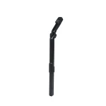


GR-4 3D Ground Scanner
The new generation GR-4 GroundTech is an advanced ground scanning and detection system that allows you to detect underground anomalies, perform 3D analysis, and evaluate the results instantly.
| Brand | Conrad, GroundTech |
|---|---|
| Depth | 15 Meter |
| Front Range | N/A |
| Made In | Turkey |
| Operating Principle | 3D imaging |
| Warranty | 2 Years |
GR-4 3D Ground Scanner & Detection System
Introduction
The GR-4 3D Ground Scanner is an advanced underground detection and ground scanning system designed for professional treasure hunting, archaeological exploration, and geophysical investigation.
Combining high-resolution 3D ground scanning technology with advanced detection modes, the GR-4 allows users to identify underground structures, metals, magnetic objects, cavities, and hidden archaeological features with exceptional accuracy.
With its powerful processing system and dual-sensor technology, the device provides clear subsurface visualization and instant scan results directly on the built-in display or through the Groundtech Portal (G-Portal) 3D/4D analysis software.
Next-Generation Ground Scanning Technology
The GR-4 detection system introduces a new generation of deep ground scanning technology, enabling users to analyze underground anomalies and locate buried objects such as:
-
gold and precious metals
-
buried treasure
-
underground cavities
-
tunnels and chambers
-
archaeological structures
-
tombs and hidden rooms
Using the advanced G-Portal visualization platform, scanning results are displayed in 3D and 4D models, allowing users to easily distinguish between:
-
magnetic metals (iron and steel)
-
non-magnetic metals (gold, silver, copper)
This intelligent visualization system makes interpretation faster and significantly improves field accuracy.
Who Should Use the GR-4?
The GR-4 3D ground scanning system is designed for professionals who require reliable and precise underground detection.
It is ideal for:
-
Professional treasure hunters
-
Archaeologists
-
Geophysical surveyors
-
Underground structure investigators
-
Exploration teams and researchers
Its portable design and intuitive interface make it suitable for both beginners and experienced users.
Key Features of the GR-4
6 Advanced Scanning Modes
The GR-4 includes six built-in scanning systems that allow flexible exploration depending on terrain and target type.
These modes include:
-
3D Ground Scanning
-
Live Scan Mode
-
Pinpointer Mode
-
Advanced detection systems for deeper investigation
This versatility allows users to perform quick reconnaissance scans or detailed underground analysis.
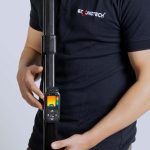
Compact & User-Friendly Design
The GR-4 has been designed with ease of use and portability in mind.
Its compact structure and intuitive interface allow users to operate the system efficiently in the field without complicated setup procedures.
High-Sensitivity Dual Sensor Technology
The system integrates MFS-2 Dual Sensor Technology with a Gradiometer ±2000 µT, providing:
-
high-precision magnetic detection
-
reduced scanning errors
-
deeper underground penetration
-
improved detection stability
Combined with a 240 MHz high-speed processor, the GR-4 delivers high-resolution detection data in real time.
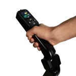
Standalone Operation with Multi-Language Support
The GR-4 features a high-resolution color display, allowing the device to function completely without requiring a smartphone or tablet.
Additional features include:
-
11 device interface languages
-
25 languages supported in the mobile application
-
intuitive visual scanning interface
This ensures ease of use for international users.
3D Ground Scanning & Data Reporting
During scanning operations, all settings and results are displayed directly on the GR-4 integrated screen.
For advanced visualization and reporting, the device connects via Bluetooth 4.2 BLE to the G-Portal mobile application, available for Android and iOS.
Using the app, users can:
-
generate 3D and 4D underground models
-
analyze subsurface structures
-
produce detailed exploration reports
-
store and review scan data
Package Contents
The GR-4 package includes:
-
GR-4 Main Control Unit
-
MFS-2 Dual Sensor Module
-
Carrying Bag
-
Charging Adapter
-
User Manual
This complete package ensures users are ready to begin scanning immediately after setup.
Detection Performance
The GR-4 3D ground scanning system can reach detection depths of up to 15 meters, depending on:
-
soil composition
-
target size
-
underground conditions
Compared with standard metal detectors, the GR-4 can locate larger buried objects and subsurface structures at significantly greater depths.
Technical Specifications
| Feature | GR-4 |
|---|---|
| System | 3D Ground Scanner |
| Sensor Technology | MFS-2 Dual Sensor (Gradiometer ±2000 µT) |
| Processor | 240 MHz CPU, 12-bit A/D |
| Detection Depth | Up to 15 meters |
| Scanning Modes | 3D Ground Scan, Live Scan, Pinpointer, Advanced Modes |
| Analysis Software | G-Portal (Android & iOS) |
| Languages | 11 device / 25 app |
| Battery | 3.7V Li-ion rechargeable |
| Wireless | Bluetooth 4.2 BLE |
| Operating Temperature | 0°C – 70°C |
| Storage Temperature | -20°C – 60°C |
| Charging | Type-C 25W adapter |
| Warranty | 2 Years |


Reviews
There are no reviews yet.